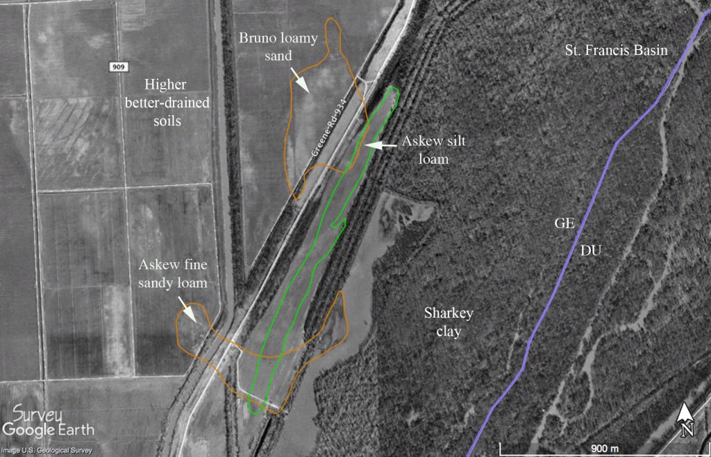
Recent archaeological investigation of a small parcel in the Malden Plain of eastern Greene County, Arkansas turned up some limited but fairly interesting surface evidence for Dalton period (ca. 8500-7900 BC) occupation of natural levees and small islands at the head of a side tributary of the St. Francis River (Childress et al. 2019). Our fieldwork demonstrated that prehistoric lithic artifacts were discontinuously distributed on slightly elevated sand and silt deposits within an extensive flat of heavy clay soils (Figure 1; distributions after Fowlkes 2006; Robertson 1969). Six higher density nodes of surface material on the edge of the bottom, ranging in size from approximately 100 to 4,500 square meters, were recorded as sites 3GE522–3GE527. Artifacts, which included diagnostics from several different time periods, were restricted to the plowzone, and extensive shovel testing of the landforms failed to provide evidence of intact midden or features at any of the site locations.
While the surface collections contained no classic Dalton projectile points, several unifacial and bifacial tools, along with a fairly distinctive modified cobble, are considered signatures of Late Paleoindian occupation of the floodplain margin (Figure 2).
A lanceolate form biface (Figure 2c) found at 3GE522 does not strictly conform to any defined Paleoindian point type and lacks the characteristic pronounced basal concavity, thinning, or grinding of many early projectile points. However, Sam McGahey (2000:27-31) has described morphologically similar specimens from northern Mississippi as Lanceolate Dalton, citing Carl Chapman’s (1948) original definition of the type based on material from southeast Missouri. In a recent summary of the North American Paleoindian record, David Anderson (2014:917) points out that comparable unfluted lanceolate shaped bifaces have been documented in pre-Clovis, Dalton, and later Paleoindian contexts in several localities. Additionally, it is a well-made point and is knapped from an exotic-looking, sugary piece of banded orthoquartzite that contains small lenticular chert inclusions. Several small step fractures on both faces indicate that the raw material block or cobble was challenging to reduce, so it was apparently made by a very skilled knapper. Although it may be exotic to the local area, similar raw material is reportedly found in the cobble deposits of nearby Crowley’s Ridge (McCutcheon and Dunnell 1998; Morse 1997:15).
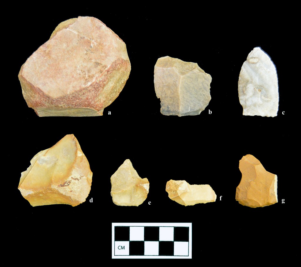
Several well-made unifacial tools, including two formal endscrapers (Figure 2e and g) and an edge-modified small blade (Figure 2f) were all struck from relatively small cobbles of tan gravel that were probably also obtained from the short streambeds draining Crowley’s Ridge. All of these tools have remnant cortex on the dorsal face (the primary working edge of the tools is on the bottom margin as shown in the photograph) clearly indicating that they were made on primary or secondary decortication flakes. The largest of the unifaces (Figure 2d) still retains a sharp, low-angled working edge that must have been used more for slicing than scraping. One of the formal endscrapers from 3GE524 (Figure 2g) may have also had a graver spur on one side. No spokeshaves or utilized pièce esquillées, characteristic of assemblages of comparable antiquity, were found on the site surfaces. Nearly identical unifacial tools have been described from the Sloan site (Morse 1997), located about 35 km due west of the site area on the opposite side of Crowley’s Ridge.
In addition to the more formal unifacial tools, a single large flake of extremely high-quality, waxy brown and black banded chert may have been brought to the local area during the Dalton occupation (Figure 2b). While there are indications of light use on one of the sharper edges of this flake, it was not significantly modified after detachment. There is one small area of very thin cortex on the dorsal surface immediately opposite the bulb of percussion, but it is not much different in color or appearance than the interior of the stone. This flake may thus have been struck from a quarried tabular block rather than a stream cobble. Our recent work with a large collection of chipped stone from a rockshelter in Newton County, Arkansas leads us to conclude that this raw material is not found in the limestone formations of the Ozarks, and it is not remotely similar to any of the specimens shown in the color plates of Jack Ray’s (2007) lithic raw material guide for that region. While exotic chert is certainly not diagnostic of any particular temporal interval, transport of high-quality raw material over great distances is a hallmark of highly mobile Paleoindian foragers.
Finally, a fairly unusual edge-abraded cobble (244.8 grams) of coarse-grained quartzite recovered from 3GE527 (Figure 2a) is also considered to be a Dalton-era artifact (cf. Morse 1997:44-51; Figure 3.16f). The cortex of the cobble, which is extremely smooth and water-worn, is missing from nearly the entire perimeter, but the exposed granular interior of the piece does not exhibit any well-defined negative flake scars. Removal of the cortex thus may have been accomplished by controlled heat crazing rather than direct percussion (the outer zones of the stone are redder than the interior, possibly due to heat treatment). The most extensive use of the coarse edge is on the lower portion as shown in the photograph. The cobble also has a shallow pit on one surface (down in the photograph) that suggests multi-functional use as a bipolar anvil stone. Running across the bipolar pit are a series of extremely shallow, very closely spaced parallel grooves or striations oriented along the long axis of the stone. It is not clear what kind of action produced these faint but distinctive marks, but platform preparation of a biface margin is certainly a possibility. This multi-functional artifact seems to correspond to one of the “bewildering array” of Dalton-era cobble tools described for this portion of the Mississippi Valley (Morse and Morse 1983:71-80).
None of the artifacts found during the recent survey work, when considered in isolation, would have provided enough evidence to postulate the occupation or use of this portion of the St. Francis Basin during the Late Paleoindian period. However, taken together and situated within the significant body of previous and ongoing research regarding the earliest portion of the North American archaeological record, the stone tools may be used to make a fairly strong case for the identification of land use here in the period ca. 12,500 to 11,000 cal. BP. Significant density of earlier Paleoindian foragers in this portion of the Central Mississippi Valley is clear from the distribution of Clovis and related fluted point types, with 35 percent of the state’s total mapped in Greene, Craighead and Clay counties alone. This density apparently continues into adjacent portions of the Malden Plain near Crowley’s Ridge (O’Brien and Wood 1998; Morrow 2006, 2019). Given the clear and mounting evidence for pre-Clovis occupation of the continent (e.g., Fagundes et al. 2008), we may infer that the earliest foragers entered the region many centuries, and perhaps millennia, before the advent of distinctive fluted point technology. From this ancient base the well-documented Dalton groups of the region developed. It seems significant that the locale reported herein, at the head a small tributary near a section of swampy land in a setting very similar to the nearby Sloan site, is within one of the postulated Dalton band areas along this stretch of the St. Francis River. The mapped extent of the foraging catchment covers about 3,000 km2 and is centered on a “reported major concentration” of Dalton material found about 27 km to the northeast of the project area in the vicinity of White Oak Ridge in extreme northeastern Greene County (Morse 1997:123-139; Morse and Morse 1983:Figure 4.1).
Original citation: Childress, M.R., and C.A. Buchner. 2020. Evidence of Dalton Occupation along the St. Francis River, Greene County, Arkansas. Field Notes, Newsletter of the Arkansas Archeological Society 412:7-10.
References Cited
Anderson, D.G. 2014. Paleoindian and Archaic Periods in North America. In The Cambridge World Prehistory, edited by P. Bahn and C. Renfrew, pp. 913-932. Cambridge University Press, Cambridge, UK.
Chapman, C.H. 1948. A Preliminary Survey of Missouri Archaeology, Part IV. Missouri Archaeologist 10(4):135-164.
Childress, M.R., C.A. Buchner, and A. Saatkamp. 2019. Archaeological Survey of the Big Island and Below Piggot/Nimmons Borrow Areas, St. Francis Maintenance and Supplemental Seepage Remediation Project, Clay and Greene Counties, Arkansas. Panamerican Consultants, Memphis. Report submitted to the U.S. Army Corps of Engineers, Memphis District.
Fagundes, N.J.R., R. Kanitz, R. Eckert, A.C.S. Valls, M.R. Bogo, F.M. Salzano, D.G. Smith, W.A. Silva, Jr., M.A. Zago, A.K. Ribeiro-dos-Santos, S.E.B. Santos, M.L. Petzl-Erler, and S.L. Bonatto. 2008. Mitochondrial Population Genomics Supports a Single Pre-Clovis Origin with a Coastal Route for the Peopling of the Americas. The American Journal of Human Genetics 82:583-592.
Fowlkes, D.H. 2006. Soil Survey of Greene County, Arkansas. USDA, Soil Conservation Service in cooperation with the Arkansas Agricultural Experiment Station.
McCutcheon, P.T., and R.C. Dunnell. 1998. Variability in Crowley’s Ridge Gravel. In Changing Perspectives on the Archaeology of the Central Mississippi Valley, edited by M.J. O’Brien and R.C. Dunnell, pp. 258-280. University of Alabama Press, Tuscaloosa.
McGahey, S.O. 2000. Mississippi Projectile Point Guide. Mississippi Department of Archives and History Archaeological Report No. 31. Jackson.
Morse, D.F. 1997. Sloan: A Paleoindian Dalton Cemetery in Arkansas. Smithsonian Institution Press, Washington, DC.
Morse, D.F., and P.A. Morse. 1983. Archaeology of the Central Mississippi Valley. Academic Press, New York.
Morrow, J. 2006. The Paleoindian Period in Arkansas, between approximately 13,500 and 12,620 calendar years ago. Field Notes No. 331:3-9. Arkansas Archeological Society.
Morrow, J. 2019. What is a Sloan Point? Field Notes No. 410:8-13. Arkansas Archeological Society.
O’Brien, Michael J., and W. Raymond Wood. 1998. The Prehistory of Missouri. University of Missouri Press, Columbia.
Ray, J. H. 2007. Ozarks Chipped Stone Resources: A Guide to the Identification, Distribution, and Prehistoric Use of Cherts and Other Siliceous Raw Materials. Special Publication No. 8. Missouri Archaeological Society, Columbia. Robertson, N.W. 1969. Soil Survey of Greene County, Arkansas. USDA, Soil Conservation Service in cooperation with the Arkansas Agricultural Experiment Station.
